
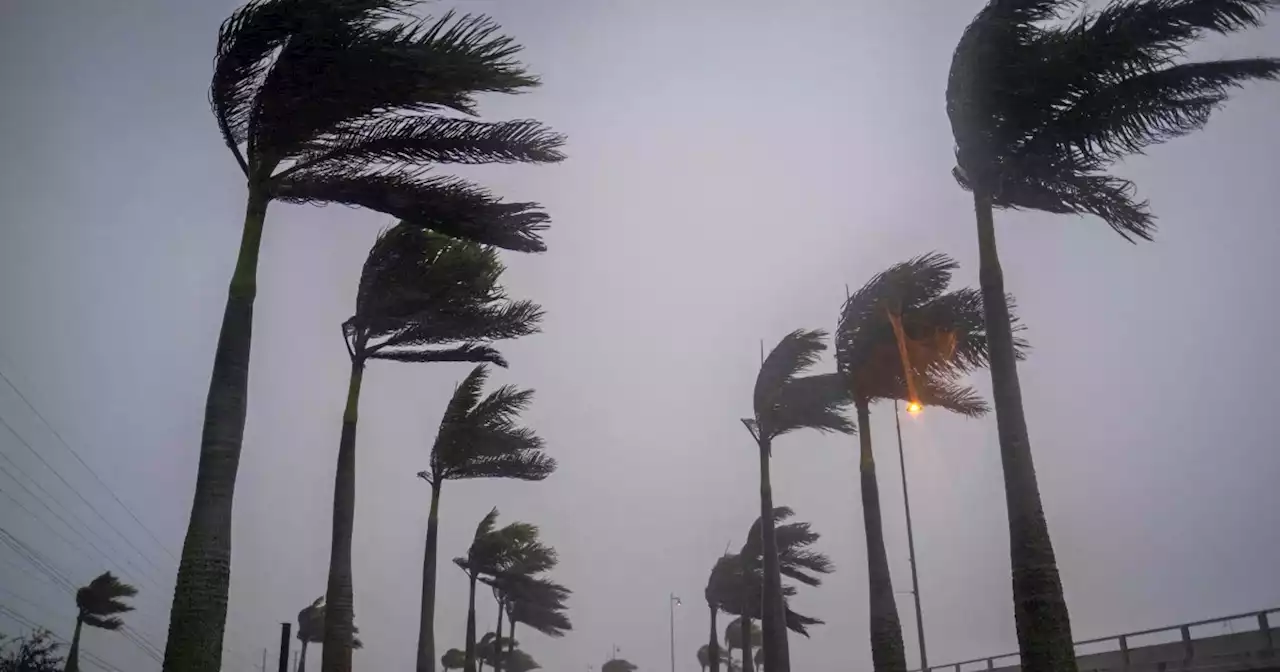
Hurricane Ian isn't expected to make landfall in South Carolina until this afternoon, but flooding has forced road closures in Charleston, and winds near the city are gusting at hurricane speeds.
now covers all of the South Carolina coast and part of the North Carolina shore up to Cape Fear — meaning hurricane conditions are expected within that area.
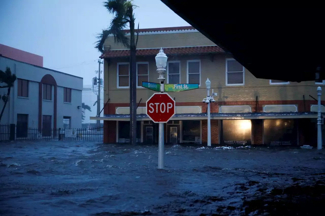
Hours ahead of Ian's arrival, a weather buoy in the ocean 41 nautical miles southeast of Charleston recorded winds of about 75 mph, with waves as tall as 21 feet, theCoastal communities again brace for Ian's storm surgepredicts Ian will make landfall northeast of Charleston, between the port city and Myrtle Beach. A large swath of the coast could see storm surge waters reach 6 feet above ground, with more than 9 feet possible in some spots.
Charleston County, which includes around 100 miles of coastline, has declared an emergency and opened shelters for people who want to sit out the storm in safe spaces and higher ground. But the county had toJust north along the coast, Georgetown County urged people in flood-prone areas to keep an eye on weather warnings — but in contrast to Charleston, the countythat it has no plans to open shelters. It also eschewed other steps, such as offering sandbags, saying people can buy them at stores.
There is no evacuation order in effect, but residents in low-lying and flood-prone areas should keep a close eye on conditions.
Australia Latest News, Australia Headlines
Similar News:You can also read news stories similar to this one that we have collected from other news sources.
 Live Updates: Charleston airport closed as Ian approaches'Only in Florida.' A woman and a dog running through a flooded park in Orlando, Florida, despite high waters following Hurricane Ian on Thursday. Credit: GanaBean via Storyful Get the latest on Hurricane Ian here -- KPRC2 HurricaneIan Ian
Read more »
 Hurricane Ian live updates: Millions without power as Ian downgraded to tropical stormMore than two million people across Florida were without power, while some were trapped in flooded homes on Thursday after Hurricane Ian walloped the state.
Read more »
 Hurricane Ian live updates: Ian downgraded to tropical storm; over 2.5M lose power in FloridaIan weakens to tropical storm as 2.5M lose power in Florida. Virginia, Georgia, Carolinas under states of emergency. Follow coverage.
Read more »
 Hurricane Ian: Manatees at Spring Park fighting Hurricane Ian storm surge* LOCATIONS AFFECTED\n- Bonaire\n- Centerville\n- Clinchfield\n- Elberta\n- Elko\n- Grovania\n- Grove Park\n\n* WIND\n- LATEST LOCAL FORECAST: Below tropical storm force wind\n- Peak Wind Forecast: 15-25 mph with gusts to 45 mph\n\n- THREAT TO LIFE AND PROPERTY THAT INCLUDES TYPICAL FORECAST\nUNCERTAINTY IN TRACK, SIZE AND INTENSITY: Potential for wind 39\nto 57 mph\n- The wind threat has remained nearly steady from the\nprevious assessment.\n- PLAN: Plan for hazardous wind of equivalent tropical storm\nforce.\n- PREPARE: Remaining efforts to protect property should be\ncompleted as soon as possible. Prepare for limited wind\ndamage.\n- ACT: Move to safe shelter before the wind becomes hazardous.\n\n- POTENTIAL IMPACTS: Limited\n- Damage to porches, awnings, carports, sheds, and unanchored\nmobile homes. Unsecured lightweight objects blown about.\n- Many large tree limbs broken off. A few trees snapped or\nuprooted, but with greater numbers in places where trees\nare shallow rooted. Some fences and roadway signs blown\nover.\n- A few roads impassable from debris, particularly within\nurban or heavily wooded places. Hazardous driving\nconditions on bridges and other elevated roadways.\n- Scattered power and communications outages.\n\n* STORM SURGE\n- LATEST LOCAL FORECAST: Life-threatening storm surge possible\n- Peak Storm Surge Inundation: The potential for 4-6 feet\nabove ground somewhere within surge prone areas\n- Window of concern: through Friday evening\n\n- THREAT TO LIFE AND PROPERTY THAT INCLUDES TYPICAL FORECAST\nUNCERTAINTY IN TRACK, SIZE AND INTENSITY: Potential for storm\nsurge flooding greater than 3 feet above ground\n- The storm surge threat has remained nearly steady from the\nprevious assessment.\n- PLAN: Shelter against life-threatening storm surge of\ngreater than 3 feet above ground.\n- PREPARE: Flood preparations and ordered evacuations should\nbe complete. Evacuees should be in shelters well away from\nstorm surge flooding.\n- ACT: Remain shel
Read more »
 Hurricane Ian live updates: Hundreds of rescues in Florida as Ian eyes CarolinasLATEST: City of Sanibel officials said Thursday evening they have confirmed at least two fatalities. This brings the overall death toll from Ian to at least 11 that have been confirmed so far.
Read more »