
How bad are Canada's wildfires and where is all this smoke coming from?
Several maps from Canadian government agencies as well as NASA in the United States help explain all that.
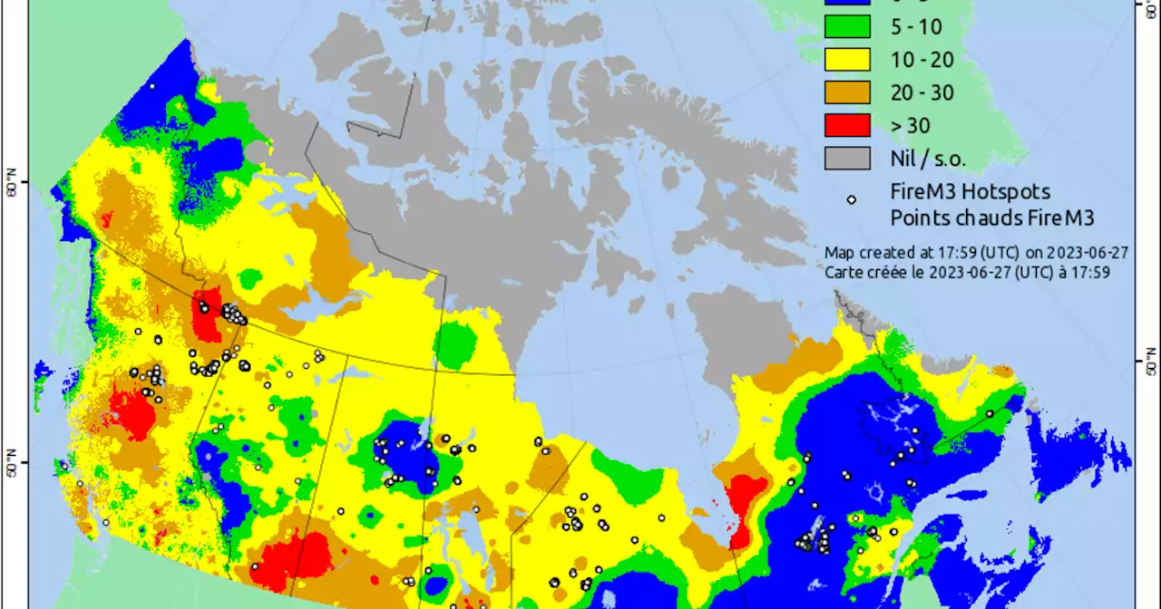
This map shows several hotspots in Ontario, directly north of Chicago. These hotspots represent fires from forests, grass, cropland, or logging debris. A hotspot may represent one fire or one of several hotspots representing a larger fire, according to Canada's Department of Natural Resources.Forecasters with the National Weather Service in Chicago have acknowledged that making those predictions can be difficult, especially because Chicago doesn't typically experience these conditions.
483 active fires were burning in Canada on Wednesday, according to the latest interagency tally. That's down from 490 active fires reported on Tuesday. The map below shows areas with the most fires. The highest number of active fires is in Quebec, with 113, down from 117 on Tuesday. British Columbia, along Canada's west coast, had the second-highest number of active blazes — 94, which was down from 99 the previous day — followed by Alberta and Ontario.
The fire risk is high or extreme in most of the country , which experts say is rare, especially this time of year. It is worst in British Columbia, Alberta, and Saskatchewan. The map below shows the historical norm for the number of fires in the country at this time of year. Thanks for reading CBS NEWS.Please enter valid email address to continue
Australia Latest News, Australia Headlines
Similar News:You can also read news stories similar to this one that we have collected from other news sources.
 Supreme Court Upholds State Courts’ Power to Prevent GerrymandersThe Supreme Court said legislatures drawing congressional districts are bound by election protections in state constitutions, dealing a blow to GOP aspirations to sideline state courts from overseeing federal elections
Read more »
 ‘Indiana Jones and the Dial of Destiny’ Trailer Maps Out Indy’s Treasured History‘Indiana Jones & the Dial of Destiny’ Trailer Maps Out a Treasured History
Read more »
 Canadian wildfire maps show where fires continue to burn across Quebec, Ontario and more provincesCanada is experiencing its most destructive wildfire season on record, as hundreds of blazes burning from coast to coast continue to send tremendous plumes of smoke into the atmosphere.
Read more »
 WSJ News Exclusive | Ecstasy-for-Medicine Advocate MAPS Looks for Cash LifelineMAPS, a nonprofit, is working on an $85 million private share sale to keep itself afloat until mid-2024, when it hopes to start selling MDMA in the U.S.
Read more »
Canada wildfire smoke pours into Upper Midwest and Great Lakes, causing poor air qualityWildfire smoke from near Montreal and Ottawa in eastern Canada is causing unhealthy air across parts of the northern U.S.
Read more »
 Chicago Reeks of Smoke as Air Quality Alert Issued Through Wednesday — Blame Canada’s Wildfires, AgainUpdate: Chicago's air quality has now hit very unhealthy levels, meaning the risk of health effects is increased for everyone. An Air Quality Alert has been issued and runs through Wednesday.
Read more »