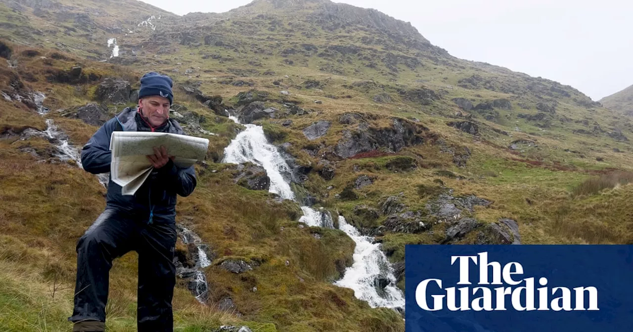
This article recounts the author's experience on a navigation course in Snowdonia, focusing on the importance of understanding contours on maps.
Maps can be cumbersome things. Especially when it’s windy. They can be pretty confounding even when the elements are in your favour. But we’ll come to that.We were on a hill – not the technical term – in Snowdonia (Eryri national park), attempting to find first a path, then a boundary line, and then a spur of land – at night-time. Each member of our group was equipped with a map, a compass and a head torch. The wind was high, the sun was down and it could have all felt like an uphill slog.
But it was, in fact, exhilarating. The last time I did this, and the last time I felt this energised by the elements and shadowy surroundings, I was 11 years old and yomping about with the Scouts. The first recce lifted us out of the rain in Capel Curig and up into the blue-skied hills above Conwy Bay Back then, I would have been in the rump of the group, while an older and more responsible boy was entrusted with the map and compass to lead our little troop across craggy terrain. Ever since, I’ve always managed to buddy up with a more technically gifted walker able to read the runes. But I’ve never lost the topography of envy, and the slight sense of unease about striking out alone or straying too far from waymarked paths.Which is why I find myself sitting in a classroom with five other learners on a two-day navigation course at Plas y Brenin, the national outdoor centre, in Capel Curig. The first thing we are told by our instructor, Grace, is that the contour is the king. “Other things on the map, such as boundaries, buildings, woods and paths, can change, but contours are less likely to.” These reddish-brown lines spaced at regular intervals paint a two-dimensional picture of the landscape around us and tell us whether it’s flat (widely spaced contours), undulating (round) or steep (close together). They tell you which way is up (the numbers on every fifth contour will be legible) and which is down (numbers will be upside down
NAVIGATION SNOWDONIA MAPS CONTOURS OUTDOOR EDUCATION
Australia Latest News, Australia Headlines
Similar News:You can also read news stories similar to this one that we have collected from other news sources.
 Mastering the Ramp Shot: Tips from a Cricket CoachLearn how to execute the innovative ramp shot in cricket with guidance from Melbourne Renegades WBBL coach Simon Helmot. The article breaks down the technique, highlighting key principles and offering insights from Sam Konstas's daring attempt during the Boxing Day Test.
Read more »
 Hourglass figure ideal for mastering art of hula hooping, study findsResearchers at New York University conclude a narrow waist and large hips are optimal for keeping a hoop spinning
Read more »
 Can I survive for 24 hours without GPS navigation?Spatial memory is a use-it-or-lose it commodity, so I gave life without Google Maps a try
Read more »
 AIATSIS Map: A Legacy of Indigenous KnowledgeThis article explores the history and significance of the AIATSIS map, a visual representation of the diverse Aboriginal and Torres Strait Islander communities in Australia. Created for the 1996 'Encyclopedia of Aboriginal Australia', the map aims to counter the colonial simplification of the continent's geography. While the encyclopaedia has become outdated, the map remains a valuable tool for understanding Indigenous cultural diversity.
Read more »
 Syria in a map: Who controls the country now Assad is gone?The collapse of the Assad regime has fragmented Syria's territory, with several armed groups now jostling for control and international players anxious to preserve their regional interests.
Read more »
 Ukraine war briefing: Nato warns that Putin wants to ‘wipe Ukraine off the map’Nato secretary general Mark Rutte says people should gird themselves for the prospect that Russia might try to use ‘swarms of drones’ in Europe. What we know on day 1,024
Read more »