
Tropical Storm Orlene is forecast to become a hurricane Saturday.
Located around 235 miles south-southwest of Cabo Corrientes, Orlene was moving north Saturday morning at nearly 5 mph, according to the National Hurricane Center. By Saturday night, the storm is expected to move north-northeastward at a"slightly faster speed."
The storm's maximum sustained winds were near 65 miles per hour, with even higher gusts, and tropical-storm-force winds extended out up to 45 miles from the center of the storm. The weather agency noted"steady strengthening is expected through Sunday."to eventually weaken before reaching the coast of mainland Mexico early next week.
Certain portions of Mexico could be in for three to five inches of rainfall, with local amounts reaching ten inches, creating the risk of flash flooding and landslides. The National Hurricane Center warned of"life-threatening surf and rip current conditions" along the coast of southwestern Mexico and the extreme southern part of the Baja California peninsula.
Areas across the coast of mainland Mexico were under tropical storm warnings and watches as well as hurricane watches. The National Hurricane Center said it expects more advisories will be issued throughout the day on Saturday. those in impacted areas to monitor local media and the National Hurricane Center for updates on the storm, seek shelter if needed and to check with airlines for potential flight impacts.
Australia Latest News, Australia Headlines
Similar News:You can also read news stories similar to this one that we have collected from other news sources.
 Tropical Storm Orlene forms off Mexico's Pacific coastMEXICO CITY (AP) — Tropical Storm Orlene formed off Mexico’s Pacific coast Thursday and was forecast to strengthen to a hurricane before making a projected landfall early next week. The U.S. National Hurricane Center said Orlene had maximum sustained winds of 45 mph (75 kmh) and was moving west-northwest at 10 mph (17 kmh).
Read more »
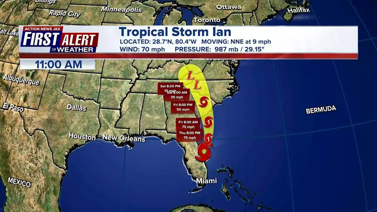 Tropical Storm Ian: Storm forecast to become hurricane again once it is off our coastIAN UPDATE: The latest track shows Ian is forecast to become a hurricane again once it is off of our coast
Read more »
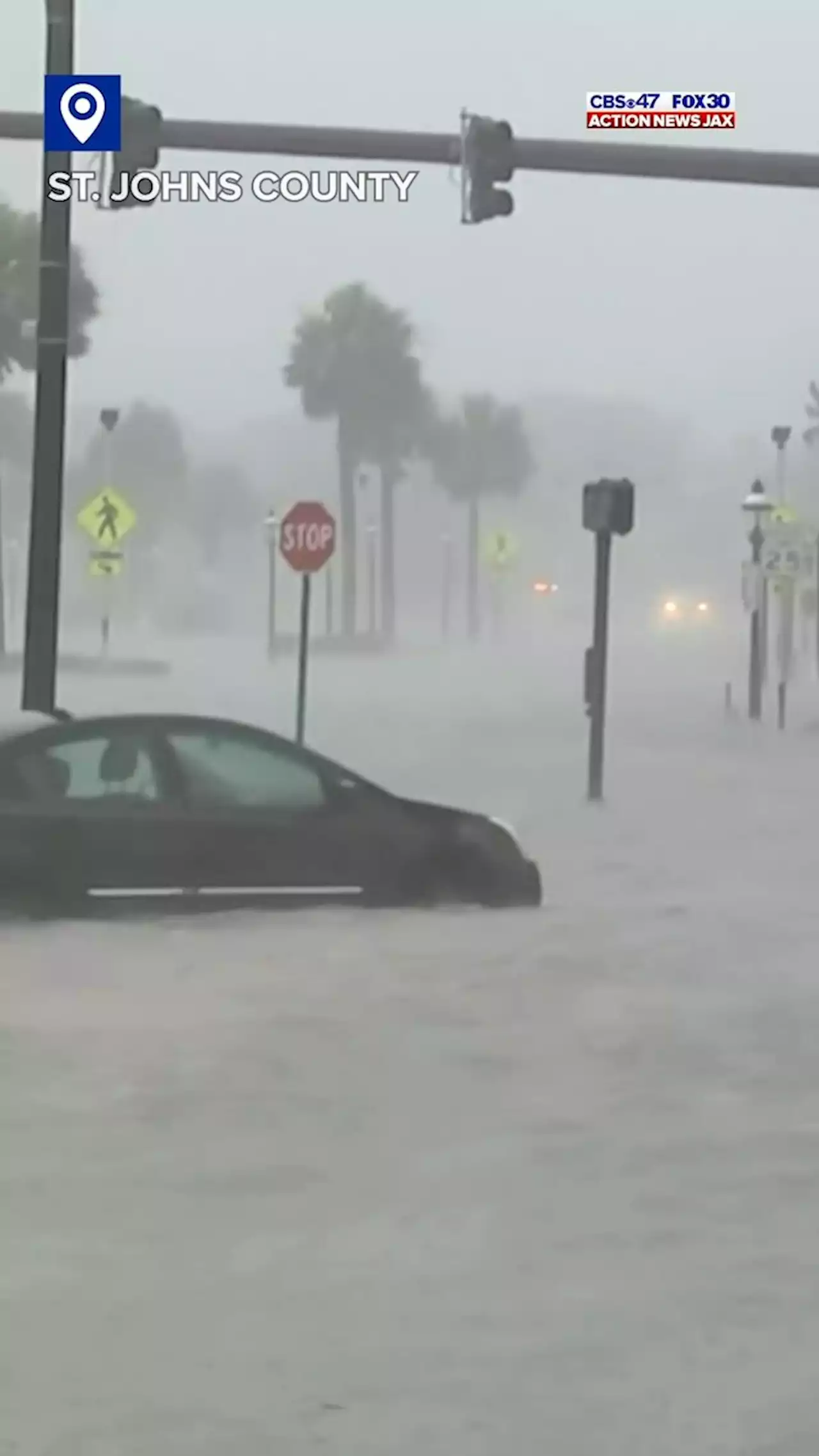 Jacksonville News, Weather, Traffic and Sports – Action News Jax* LOCATIONS AFFECTED\n- Jekyll Island\n- Glynn Haven\n- Sea Island\n- St. Simons\n- Country Club Estate\n- Dock Junction\n\n* WIND\n- LATEST LOCAL FORECAST: Equivalent Tropical Storm force wind\n- Peak Wind Forecast: 35-45 mph with gusts to 70 mph\n- Window for Tropical Storm force winds: until Friday morning\n\n- THREAT TO LIFE AND PROPERTY THAT INCLUDES TYPICAL FORECAST\nUNCERTAINTY IN TRACK, SIZE AND INTENSITY: Potential for wind 58\nto 73 mph\n- The wind threat has remained nearly steady from the\nprevious assessment.\n- PLAN: Plan for dangerous wind of equivalent strong tropical\nstorm force.\n- PREPARE: Last minute efforts to protect life and property\nshould now be complete. The area remains subject to\nsignificant wind damage.\n- ACT: Now is the time to shelter from dangerous wind.\n\n- POTENTIAL IMPACTS: Unfolding\n- Potential impacts from the main wind event are unfolding.\n\n* STORM SURGE\n- LATEST LOCAL FORECAST: Life-threatening storm surge possible\n- Peak Storm Surge Inundation: The potential for 4-6 feet\nabove ground somewhere within surge prone areas\n- Window of concern: through Friday evening\n\n- THREAT TO LIFE AND PROPERTY THAT INCLUDES TYPICAL FORECAST\nUNCERTAINTY IN TRACK, SIZE AND INTENSITY: Potential for storm\nsurge flooding greater than 3 feet above ground\n- The storm surge threat has remained nearly steady from the\nprevious assessment.\n- PLAN: Shelter against life-threatening storm surge of\ngreater than 3 feet above ground.\n- PREPARE: Flood preparations and ordered evacuations should\nbe complete. Evacuees should be in shelters well away from\nstorm surge flooding.\n- ACT: Remain sheltered in a safe location. Do not venture\noutside.\n\n- POTENTIAL IMPACTS: Unfolding\n- Potential impacts from the main surge event are unfolding.\n\n* FLOODING RAIN\n- LATEST LOCAL FORECAST: Flood Watch is in effect\n- Peak Rainfall Amounts: Additional 1-3 inches, with locally\nhigher amounts\n\n- THREAT TO LIFE AND PROPERTY THAT INCLUDES TYPICAL FORE
Read more »
 Live updates: Ian has weakened to a tropical storm, continues to pummel Florida'It was definitely the roughest flight I've been on' -- NOAA Aerospace Engineer Nick Underwood flew a plane into Hurricane Ian. He shares his experience with the storm with CNN's Erin Burnett
Read more »
 Hurricane Ian brings deaths, floods, outages to Florida; system downgrades to tropical storm: LIVEFIERCE WINDS: This is the moment a meteorologist was hit by a tree branch while reporting on Hurricane Ian on a Florida street. When the storm first made landfall, forecasters say winds were at 150 mph. The latest:
Read more »